
A legendary advocate for wild country, 27-year-old Bob Marshall hiked an astounding 288 miles in eight days during the summer of 1928. Much of his arduous backcountry trip took place in the wilderness that would later bear his name.
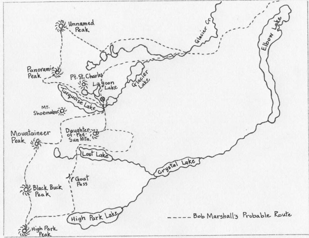
Over the years I have explored and hiked much of the area in the Mission Mountains that Bob Marshall visited during the final two days of his trip 91 years ago. I climbed most of the mountains he climbed and camped in the same area he camped. While Bob Marshall averaged 36 miles a day on his journey, I averaged 6-7 miles per day at best. After examining his careful and detailed journal entries, I traced the probable route he took on the last two days of his trip (see map).
Bob rode up to the Flathead National Forest Office in Kalispell from Missoula where he worked as a US Forest Service forester at the Northern Rocky Mountain Forest Experiment Station in Missoula. He caught a ride to a trailhead in the Echo Lake area to begin his trip on Aug. 28. During his epic journey he hiked across the Swan Range, down the South Fork of the Flathead River, across the Swan River Valley, up the Mission Mountain Range and down the Clearwater River drainage to Seeley Lake. He climbed 12 mountains, visited four fire lookouts and walked an average of 36 miles a day during his eight-day trip.
A noted hiker with incredible stamina and endurance, Bob regularly took long-distance hikes. As one source noted, friends and acquaintances rarely hiked with Bob a second time because his pace was too fast and the distances too great.
Bob kept meticulous records of his trip in a field journal. He seemed fascinated with numbers, noting his daily mileage, starting times and arrival times. He recorded exact distances between locations, including total distances for each day.
The final two days of Bob Marshall's grand adventure were spent hiking across Swan Valley, exploring the Turquoise Basin area in the Mission Mountains and finally hiking all the way to Seeley Lake.
After spending the majority of the first six days hiking and climbing in the South Fork, Bob crossed Gordon Pass and spent the night at the Holland Lake Guard Station located at the present-day Holland Lake beach.
On the seventh day he was on the move by 7 a.m. He hiked past the Gordon Ranch and continued along the "Elbow Lake Road" that led to the present-day Lindbergh Lake. He proceeded to Elbow Lookout and headed to Glacier Creek arriving at noon. From there it took him a mere one hour and ten minutes to hike to Lagoon Lake arriving at 1:10 p.m.
The original trail from Glacier Lake to Lagoon Lake was shorter in length and steeper and rougher than the gentle grade of today's route. At this point Bob had walked 17 and a half miles. For many people this would have been more than enough hiking for one day. But the legendary hiker was just getting started.
In 1922, well-known USFS employees Theodore Shoemaker and Jack Clack led a group of photographers and writers into the Mission Mountains. The objective of the exploratory trip sponsored by the Northern Pacific Railway Company was to scout the area for future tourism promotion. They named many of the landmarks in the area. Shoemaker, along with other members of the Montana Mountaineers (an outdoor club from Missoula) made the first recorded ascent of Mountaineer Peak in 1923. That same year Shoemaker created a map of the area titled, "Turquoise Basin - Flathead National Forest." (see illustration).
No doubt Bob left the bulk of his camping gear at Lagoon Lake where the trail ended. Shoemaker had marked this spot on his map as "Area Containing Practical Camp Sites." It seems almost certain that Bob used Shoemaker's map to guide him on his journey.
From Lagoon Lake he traipsed onward to Turquoise Lake, proceeded around the lake to a pass located between Mount Shoemaker (8,644 feet) and Daughter-of-the-Sun Mountain (8,777 feet), continued on to the Mountaineer Lake area and climbed to the summit of Mountaineer Peak (9,261 feet).
After he ascended Mountaineer Peak, he scampered along the ridge in a southerly direction, climbed Black Buck Peak (8,870 feet), descended down the easterly slope where he again headed in a southerly route and ascended High Park Peak (8,480 feet). At this point in the day, Bob had walked 25 miles and climbed three mountains. But the famed hiker wasn't finished as there were still peaks to climb and miles to walk.
Bob headed back to camp using a different route. He proceeded to walk to High Park Lake and continued half-way around the northwest shore. From there he hiked up to Goat Pass and dropped down to Lost Lake. He worked his way past the lake, found a route up the cliffs into the Seepela Lake area where he summited the Daughter-of-the-Sun Mountain. Perhaps even the renowned Bob Marshall himself was feeling the toll of this rugged terrain. In the waning daylight he worked his way downward toward his camp.
All in all, on this September day, he trekked 34 miles and climbed four mountains. According to notes in his journal, he made camp at 8:35 p.m., built a fire at 8:50 p.m. and ate supper at 9:15 p.m.
On the final day of his remarkable journey, Bob woke early at 4:45 a.m. and was back on the trail again. He reached the top of Point St. Charles (8,323 feet) at 6:50 a.m. No doubt he enjoyed the sunrise for the next 20 minutes.
He then hooked around into the high basin south of the peak, continued on to Lone Tree Pass, and climbed up and around the ridge to the original Panoramic Peak (8,650 feet). From there he ran the ridge in a northerly direction to an unnamed peak (7,752 feet) before scurrying down to Heart Lake. He proceeded down to Glacier Creek, and eventually hooked around to Elbow Lake. He took a leisurely 50-minute rest break at the lake before pushing onward. He walked to the main dirt road, turned south and walked to the Seeley Lake Post Office where he ate supper at 9:30 p.m.
The final day of his trip he walked 42 miles and climbed three peaks. To say Bob Marshall was tired when he went to bed at exactly 10:10 p.m. that night might be an understatement.
Reader Comments(0)